Did you know there are over 90 waterfalls in the Columbia River Gorge? 90!
A quick day trip from Portland can bring you to some of the best Oregon waterfalls in the state. Most of them are less than an hour’s drive away too.
In this post, we’re breaking down all of the major Columbia River Gorge waterfalls with all the information you need to visit.
We’ll share basic stats like height and type, but also share some juicy details about their history or our favorite photo perspectives of each.
Let’s get started!

- How Did The Columbia River Gorge Waterfalls Form?
- Multnomah Falls Permit Information
- Columbia River Gorge Waterfalls After The 2017 Eagle Creek Fire
- The 25 Best Waterfalls In The Columbia River Gorge
- Columbia River Gorge Waterfalls On the Washington Side
- Columbia River Gorge Waterfalls Map
- MORE Oregon Adventures
The Columbia River Gorge at a Glance
Before venturing out to the Gorge, here are some things to help plan your trip:
Best Time To Visit: Late spring and summer are the most beautiful times to visit, however, they do bring the most crowds. Try to come on a weekday if possible.
Permits: You’ll need a timed-use permit to visit Multnomah Falls between May 26th and Sept 4th. You can find the $2 tickets here.
Where to Stay: If you’re looking to stay as close as possible, The Cascade Locks Best Western is a great budget-friendly choice.
How To Get Around: Most visitors drive from Portland. If you are planning a bigger Oregon road trip, I highly recommend renting a campervan from Outdoorsy. (It’s like Airbnb but for RVs!)
Don’t Forget: Some areas require a Northwest Forest Pass ($30 annually), or a Discover Pass for Washington State Parks. We’ll list that in the descriptions!

How Did The Columbia River Gorge Waterfalls Form?
So, how did the waterfalls near the Columbia River Gorge form?
First, the area went through a series of uplifts from nearby tectonic plates – this is how the Cascade Mountains formed. Secondly, volcanic activity continued to build up the surrounding area.
Between 19,000 and 15,000 years ago, the Missoula Floods happened (Western Montana/Inland Northwest).

The glacial meltwater from that ripped through the Washington and Oregon landscape on its way to the Pacific Ocean. This meant the Washington side got stripped of loose sediment, creating those slopes and rolling hills we see today.
On the other side of the water, the 60mph+ raging water stripped chunks of the mountain apart. This made once calm mountain streams into hanging waterfalls that fell off the side of the cliff. Such large chunks were stripped away that some sections even have 4,000 feet high walls!
The geology of the Columbia River Gorge is SO fascinating and you can find more about it in Oregon Encyclopedia.

Want to camp nearby the waterfalls?
Find a campsite that’s convenient for all your day hikes! The Dyrt PRO — our favorite way to save money on camping. Especially when there are an abundance of campgrounds nearby!
Unlock discounts at 1000+ campgrounds nationwide, get up to 40% off camping reservations and pay $0 extra booking fees – all with The Dyrt PRO.
Try PRO for free, no strings attached — use our code “mandagies” to get 30 days free — and start saving money on your camping trips!
Multnomah Falls Permit Information
NEW FOR 2023: In 2022, the Waterfalls Corridor (Highway 30) required a separate timed-use permit. That is NOT the case for 2023, and access is permit-free for Highway 30. However, parking is still extremely limited. The best times to come (for SOME chance of parking) would be very early in the morning, or after 5:00pm.
Because of the high visitor numbers in the past few years, the Columbia River Gorge National Scenic Area implements a permitted entry for Multnomah Falls parking lot, off I-84 on Exit 31.
The goal is to reduce congestion in these areas and provide fast and easy passage for US Forest service emergency vehicles to access the area in times of emergency.
Multnomah Falls is PERMITTED USE ONLY from May 26th-September 4th from 9 am – 6 pm daily. You can reserve permits as early as two weeks before your visit. We recommend doing this in advance – there is no way to pay for a permit on-site! You can reserve a permit for $2 here.
Don’t have time to book a ticket? You can also come BEFORE 9 am or after 6 pm, with permit-free access.

Columbia River Gorge Waterfalls After The 2017 Eagle Creek Fire
If you’re new here, it’s really important to know about the Eagle Creek Fire of 2017.
The fire was started on September 2nd, 2017 by a teenager who was lighting fireworks during a burn ban.
The fire raged out of control, consumed over 50,000 acres, and burned for three months straight. It destroyed much of the forest along Highway 30, which is where the majority of waterfalls and Columbia River Gorge hiking trails are.
Because of the fire, the Gorge landscape has changed drastically. Landslides are common because of unstable ground. High winds are dangerous, because they could push over damaged trees. Ultimately, the area is still recovering and will be for the next several decades.

Today, trail closures are frequent and sporadic, depending on the weather and natural events. Maintenance is a constant activity, with teams coming out often to clear covered trails, stabilize hillsides, and clean up debris from hiking areas.
Please be patient and understanding when you encounter closures. They are for everyone’s safety, so please respect any barriers in place.
Volunteer at the Columbia River Gorge
Maintenance wouldn’t be possible without the support of volunteers in the area! If you want to participate in a volunteer trail event, you can find some here at Friends of the Columbia River Gorge, and the US Forest Service website.
The 25 Best Waterfalls In The Columbia River Gorge

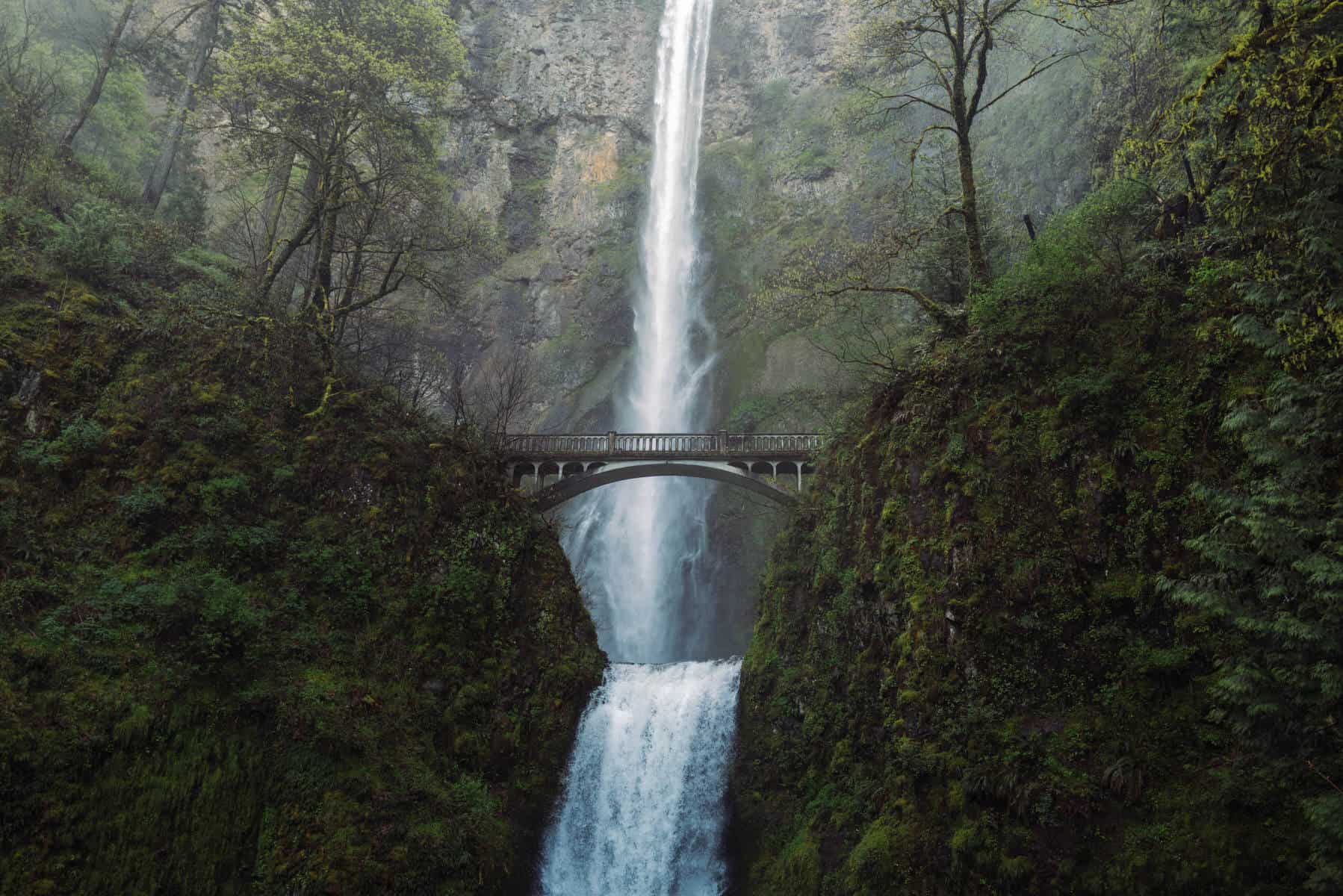
1. Multnomah Falls
- Waterfall Height: 620 feet
- Type of Falls: Cascade Falls
- Drive-Up or Hike-In: Both
- Bathrooms On-Site: Yes
Multnomah Falls is easily one of the most popular waterfalls in Oregon. Not only is it the tallest in the state, but it’s also one of the most accessible Columbia River Gorge waterfalls too!
Driving on I-84, you can see it from the road and the parking lot, even without having to stop.
Because of its popularity, it can get especially crowded on any/every nice weather weekend. It’s the most visited recreation site in the Pacific Northwest! The best time to visit is on a weekday, early in the morning.
In 2021, the Forest Service began implementing permits to visit Multnomah Falls to limit crowding and relieve traffic congestion. You must purchase a timed-reservation permit between May 24th and September 5th here.
Note: This is different from the Waterfall Corridor Timed Use Permit.
At the falls, visitors can view the two drops separated by Benson Bridge. There is a paved pathway all the way up until you reach the Multnomah Falls Upper Viewpoint. (Which is actually one of many haunted places in Oregon!)
You can extend your hike here to see even more Columbia River Gorge waterfalls by choosing:
- 2.4-Mile Multnomah Falls Trail (To see Dutchman Falls, Weisendanger Falls, and Ecola Falls)
- 9-Mile Multnomah Falls to Wahkeena Falls Loop
- 6.8-Mile Larch Mountain Trail

2. Wahkeena Falls
- Waterfall Height: 242 Feet
- Type of Falls: Tiered Plunge Falls
- Drive-Up or Hike-In: Both
- Bathrooms On-Site: Yes
“Wahkeena” in the Yakima Indigenous language is translated to “most beautiful” and we’d have to agree!
Wahkeena Falls is a double-tiered falls just barely tucked away in the trees. It’s a short walk up to the base, making it a perfect stop on your waterfalls of the Columbia River Gorge tour.
The best time of year to visit, in our opinion, is between Oregon spring break and summer season. In the early spring, the trees don’t have their leaves yet, and you have a clear view of the falls from the parking lot.
However, in the summer, the leafy trees have hidden the falls from plain sight, but you can still hear them! In the summer, you can to work a little bit more to get a view of the falls, but it’s worth it to have them revealed right in from of your eyes!
The biggest feature of Wahkeena Falls is the connection access to many other waterfalls and trails! To see even more Columbia River Gorge waterfalls, keep walking after you’ve visited Wahkeenah Falls.
You’ll reach Fairy Falls in 1/5 ish miles, and this trail also connects you to Multnomah Falls Loop trail, which includes Ecola Falls, Dutchman Falls, and Weisendanger Falls.

3. Fairy Falls
- Waterfall Height: 20 feet
- Type of Falls: Cascade Falls
- Drive-Up or Hike-In: Hike-in, 3.4 miles RT w/ 1,500 ft elevation gain
- Bathrooms On-Site: No
Fairy Falls is the waterfall you see on the extended trail from Wahkeenah Falls. It’s not very large at all, (only 20-30 feet high) but it cascades out into a dreamy fan shape, hence the name Fairy Falls! To reach it, park in the same parking lot as you would for Wahkeenah Falls.
It was actually originally called Ghost Falls, but the name got changed to Fairy Falls to represent its magic-life characteristic among the greenery, ferns, and flowers. (We think this name fits much better!)
Contrary to what you might think, Berty and I think this waterfall is best visited in the springtime, and even when it’s rainy! This is because you can experience one of the truest Pacific Northwest hiking trails when in the rain.
Along the way, you’ll climb up a narrow canyon filled with greenery and cross a few bridges with a rushing creek below.
It’s a wonderful Columbia River Gorge hiking trail to take in all the sights and sounds of the area. Just note that it is a relatively demanding hike. What it lacks in distance is made up for in elevation gain. You climb multiple switchbacks and are on an incline the entire way. Allow an extra hour to hike from Wahkeenah to Fairy falls.

4. Horsetail Falls
- Waterfall Height: 176 feet
- Type of Falls: Ironically, a cascade falls
- Drive-Up or Hike-In: Drive-Up
- Bathrooms On-Site: No
Of all the waterfalls in the Columbia River Gorge, Horsetail Falls is by far the easiest to experience and enjoy. It’s truly a “roadside waterfall” where you park your car, cross the street, and you’ve arrived!
Horsetail Falls looks exactly how it is named. This cascading waterfall looks like a horsetail as it plunges into a clear blue pool below.
The best time to visit Horsetail Falls is in the evening, around golden hour or sunset. The warm glow of the sunshine along the Gorge’s cliff walls really makes Horsetail Falls shine!
To stretch your legs a little here, you can choose to take the short trail up to Ponytail Falls. It also goes by the name Upper Horsetail Falls, and you will hear both names interchangeably. (More on this falls in the next section!)

5. Ponytail Falls
- Waterfall Height: 75ish feet
- Type of Falls: Plunge falls
- Drive-Up or Hike-In: Hike-in
- Bathrooms On-Site: No
Located right above Horsetail Falls (it’s actually an extension of it!) Ponytail Falls can be reached by taking Trail #438. This is a really interesting waterfall – once you reach it, the trail continues to run directly behind the waterfall!
This is because there is a natural cavern behind the falls that allows hikers walk to under. It’s incredibly cool, and reminds us of several waterfalls on the Trail of Ten Falls at Silver Falls State Park.
Just like Horsetail Falls, we think this waterfall is best visited during the evening. Ponytail Falls is surrounded by tall trees, and the light beams that show up in the evening are hard to beat!

6. Latourell Falls
- Waterfall Height: 249 feet
- Type of Falls: Single Plunge Waterfall
- Drive-Up or Hike-In: Both options are available
- Bathrooms On-Site: Yes
Latourell Falls is either the last or the first of the Columbia River Gorge waterfalls on your route, depending on which way you’re coming from. (It’s one of the closest waterfalls near Portland)
The falls were named after Joseph Latourell, a Columbia Gorge settler to became postmaster of the nearby post office. You can still see his family’s cabin near the park’s picnic area!
Because of its proximity to Portland (only 30 minutes away from downtown), Latourell Falls is one of the most popular waterfalls in the Columbia River Gorge.
Latourell Falls drops an impressive 249 feet, plunging down a columnar basalt cliff into a chilly pool below. If you get close to the base, it’s nearly guaranteed that you’ll get wet! The mist and spray from the falls are unavoidable!
To visit Latourell Falls, come early in the day. Because this is one of the most popular Oregon waterfalls, the parking lot fills up fast. Sometimes, it can be hard to find a spot even at 9 am on a sunny, summer day!
There are several viewing options at Latourell Falls. The distant viewpoint is just up a short hill from the parking lot. This is the closest viewpoint but also the farthest away. To get to the base, head back down to the parking lot and take the other trail (0.25 miles) and follow signs to the Lower Falls viewpoint.
For more hiking options, you can take Latourell Falls Loop Trail – a 2.0-mile hike.

7. Bridal Veil Falls
- Waterfall Height: 118 feet
- Type of Falls: Two-tiered Horsetail Cascade Falls
- Drive-Up or Hike-In: Hike-In but short, 0.5 miles RT
- Bathrooms On-Site: Yes
Bridal Veil Falls is technically a roadside falls, but you end up driving right over it on a bridge so you’d never know if you weren’t looking!
The parking lot has a large sign and it is easy to spot. Nearby, there is a grassy field with some picnic tables and a short interpretive nature walk. It’s a great stop for families or people who just want a quick break for lunch.
Reaching the falls requires a short walk on a soft-sloping path. There are two routes to take (0.5 miles total and 0.7 miles total) – one takes you to the base of the falls, and the other takes you to an overlook.
We recommend walking to the base of the falls to get the best view. The base walk has some stairs, but they aren’t too strenuous.
Once you reach Bridal Veil Falls, you’ll know why it got its name. It really does look like a bridal veil!
It is actually one of the biggest Columbia river gorge waterfalls by water volume. If you come on a rainy day, you’ll get to experience the power of its rushing water!

8. Wahclella Falls
- Waterfall Height: 350 feet (in total)
- Type of Falls: Two-tier plunge falls
- Drive-Up or Hike-In: Hike-in, 1.9 miles RT
- Bathrooms On-Site: Serviced Honey buckets ****
- Pass Required: Northwest Forest Pass
Wahclella Falls is just barely outside of the main Columbia River Gorge waterfalls area.
To reach the Wahclella Falls parking lot, from I-84, take Exit 40 which also has signs to Bonneville Dam. Head north and the parking lot should be just a few hundred yards forward.
Note: You’ll need a Northwest Forest Pass. You can get it here online before your trip – it’s $30 for the entire year.
Wahclella Falls requires a short, not too strenuous hike. The trail follows the roaring river, through a lush green canyon. Munra Falls is along the way over a footbridge almost right away, which is a bonus Columbia River Gorge waterfall!
At the end of the trail, you are rewarded with a 350-foot two-tier plunge falls, seemingly bursting forth from a small crack in the canyon wall. It’s an incredibly beautiful waterfall, and the trail itself is just as fun to hike!
9. Lower Oneonta Falls
- Waterfall Height: 100 feet
- Type of Falls: Cascade
- Drive-Up or Hike-In: Hike-In
- Bathrooms On-Site: No
Note: Oneonta Gorge has suffered significant damage from the Eagle Creek fire of 2017. Until April 2024 (or if rescinded earlier), the area within the canyon walls of Oneonta Gorge between Highway 30 and Horsetail Falls Trail Bridge (that spans Oenonta Creek) are closed for hikers due to high danger.
We will update this post when new information becomes available. Please use this description for information-purposes only right now.
Lower Oneonta Falls doesn’t quite have a trail to it, despite being less than half a mile away from the highway. It’s a true hidden gem!
To reach it, hikers must crawl over precarious log jams and forge the river, sometimes in chest-deep water. It’s quite dangerous to attempt in the springtime when water levels are high – it’s best to wait until August or September to see this Columbia River Gorge waterfall.
When it’s open, come during a hot summer weekday. The water is too cold to forge any other time of year, and the weekends can be very busy!

10. Shepperd’s Dell Falls
- Waterfall Height: 220 feet (90 feet visible)
- Type of Falls: Tiered Cascade and Horsetail Falls
- Drive-Up or Hike-In: Drive-up
- Bathrooms On-Site: No
Shepperd’s Dell Falls is one of the most forgotten waterfalls in the Columbia River Gorge, despite being SO easy to reach!
This is a two-tier (actually multiple but the main tiers are the biggest), cascade waterfall that plunges into the Youngs River below. Listen for it when crossing the beautiful arched bridge, constructed in 1914.
There is no parking lot for the falls, but there are just a few spots for cars to pull over on either side of the bridge. You’ll need to get out of the car to see it, but the trail is very short and easy, only 0.2 miles to the viewing platform.
Shepperd’s Dell State Natural Area is located on the west of the main Columbia River Gorge waterfalls, which makes it a great stop near the beginning or the end of your trip.
11. Elowah Falls
- Waterfall Height: 213 feet
- Type of Falls: Plunge falls
- Drive-Up or Hike-In: Hike-in
- Bathrooms On-Site: No
Note: Elowah Falls and Nesmith Point are currently closed due to a landslide, effective April 2021. Please click here for the most updated information about this trail status before your trip.
Elowah Falls is one of the more impressive waterfalls in the Columbia River Gorge, and one that you can see from the highway!
To get to Elowah Falls (and Upper McCord Creek Falls too – more on that in the next section) park at John B. Yeon Trailhead.
It’s located at the end of a short 1.5 miles round trip hike. This area of the Gorge suffered significantly from the 2017 Eagle Creek Fire, which is notable along your journey.
12. Upper McCord Creek Falls
- Waterfall Height: 64 feet
- Type of Falls: Twin chutes
- Drive-Up or Hike-In: Hike-in
- Bathrooms On-Site: No
Note: While Elowa Falls is closed (check here to see if it’s open again) the trail to Upper McCord Creek Falls remains open for hikers.
Upper McCord Creek Falls is upstream from Elowah Falls, and both can easily be seen in one trip. The trail is fairly short but on the challenging side (1.9 miles) and it takes you through many iconic Columbia River Gorge features along the way.
You’ll cross Moffet Creek Bridge, a steep scree slope, and several switchbacks.
En route, hike on a narrow trail that’s nearly carved out of the cliffside. If you have a fear of heights, this might be one of the Columbia River Gorge waterfalls to skip!
13. Starvation Creek Falls
- Waterfall Height: 140-220 feet (height is debated)
- Type of Falls: Two-tier cascade falls
- Drive-Up or Hike-In: Hike-in
- Bathrooms On-Site: Yes
f you are driving on I-84 East, chances are you’ll pass the sign form Starvation Creek State Park. This is one of the most overlooked waterfalls in the Columbia River Gorge, but it’s definitely worth a visit if you have the time!
Starvation Creek State Park is its own tiny park along the Columbia River Gorge and it’s the perfect stop for families. Here, you’ll find picnic tables for a lunch break, restrooms, and even access to more hiking trails.
The closest nearby hikes include Starvation Ridge Loop and Mount Defiance.
If you love to ride bikes, you can take the Historic Columbia River Highway State Trail from the park to Viento State Park.
Along this very easy 0.2 mile hike to the falls, make sure to stop and read the interpretive signs. They share the interesting history of how the falls got its name!
After an 1884 railroad incident, a passenger train found itself stuck in a snowbank for several weeks. Train passengers were kept alive (no one died from it) by residents od the Columbia River Gorge who snowshoes and skied in food and supplied to the stranded travelers.
14. Tunnel Falls
- Waterfall Height: 172 feet
- Type of Falls: Cascade/Pluge
- Drive-Up or Hike-In: Hike-in
- Bathrooms On-Site: Yes, at trailhead
If you are hiking the iconic Eagle Creek Trail, Tunnel Falls is the traditional turnaround spot for day hikers.
It’s pretty far along the trail (12 miles round trip) but definitely worth the trek. It gets the name Tunnel Falls because the trail runs along the cliff’s edge, and continues behind the waterfall!
(Similar to the ones on the Trail of Ten Falls at Silver Falls State Park.)
Thankfully, it was one of the few areas that remained in a similar state after the Eagle Creek Fire of 2017. This lush, green grotto still drips with ferns, moss, and greenery in all directions.
It’s best to visit Tunnel Falls on a drier stint of weather. This section of trail is notoriously known for being the most dangerous because of the slick ground and steep ledges. Come when it’s dry(ish!)
15. Punchbowl Falls
- Waterfall Height: 35 feet
- Type of Falls: Punchbowl
- Drive-Up or Hike-In: Hike-in
- Bathrooms On-Site: Yes, at trailhead
Much earlier along the Eagle Creek Trail is the magical Punchbowl Falls.
This small (but still awe-inspiring) waterfall plunges into a large pool that is often used as a swimming hole on hot summer days. (Just remember to enter from the Lower Punchbowl Falls Area).
Jumping into the basin from the top is strictly prohibited, although many don’t choose to listen and get severely hurt in the process.
Just a reminder: Calling a rescue team into a trail to save you is not only expensive for you, but it takes emergency personel away from others who may need help too. It’s always a wise idea to follow the rules!
This waterfall actually sparked geologists to name a brand new designation for waterfalls – The Punchbowl. Punchbowl Falls is an iconic feature of the Pacific Northwest, and can often be found on postcards, calendars, and magnets!
16. Loowit Falls
- Waterfall Height: 88 feet
- Type of Falls: tiered horsetail
- Drive-Up or Hike-In: hike-in
- Bathrooms On-Site: Yes, at the trailhead
Loowit Falls is located three miles into the Eagle Creek trail, and is the first major Columbia River Gorge waterfall that hikers can enjoy along this hike.
According to Columbia River Gorge area lore, “Loowit” was an indigenous woman who tended an eternal fire on the Bridge of the Gods. Upon her death, she transformed into Mt. St. Helens, which is what most Native American tribes call Loowit still today.
This section of the trail was blasted out of the rock, and conveniently provides a spectacular frame for Loowit Falls in the near distance.
You can see the falls from High Bridge which spans across the canyon, but keep going further because there is a closer viewpoint for Loowit Falls.
17. Metlako Falls
- Waterfall Height: 82 feet (Debated to be between 100-150 feet)
- Type of Falls: Horsetail falls
- Drive-Up or Hike-In:
- Bathrooms On-Site:
Note: Metlako Falls Spur #440A trail is permanently closed due to a Dec. 2016 landslide that destroyed the viewpoint area. If there are plans to open this viewpoint again, it will be posted here.
Metlako Falls is the lowest elevation waterfall along the Eagle Creek Trail, but it’s definitely not the shortest! This horsetail falls burst forth from the cliff’s edge and plunge into a pool right below it.
You can see the entire waterfall from the approach on the main trail right after you see the 100-foot Sorenson Falls.
It is said to be 82 feet high, but Forest Service members constantly doubt that height and believe it to be much taller than described – more like 100-150 feet.
18. Hole-In-The-Wall Falls
- Waterfall Height: 120 feet
- Type of Falls: Cascade falls (multiple tiers)
- Drive-Up or Hike-In: Hike-in
- Bathrooms On-Site: Yes
Hole-In-The-Wall Falls is actually man-made, making it one of the newest Columbia River Gorge waterfalls!
Around 1938 as they were constructing the original Highway 30, Warren Creek would continually flood, making it an ongoing hazard.
The maintenance crew decided that diverting the creek would be the best option. They blasted an alternate flow channel and pipe to alter the flow pattern of the creek, thus Hole-In-The-Wall falls was born!
You can easily see Hole-In-The-Wall Falls and several other Columbia River Gorge waterfalls in just one easy, universal access trail.
Starting at the Starvation Creek Trailhead, you can walk the paved ~1.5-mile loop and see Starvation Creek Falls (0.1 miles), Cabin Creek Falls (0.3 miles), Hole-In-The-Wall Falls (0.6 miles), and Lancaster Falls (0.8 miles).
19. Dry Creek Falls
- Waterfall Height: 75 feet
- Type of Falls: Horsetail Falls
- Drive-Up or Hike-In: Hike-in
- Bathrooms On-Site: Yes
Dry Creek Falls is a horsetail waterfall that drops into a columnar basalt canyon, covered in lust, green moss.
If you want to try a little section of the PCT, Dry Creek Falls trail is an excellent way to do so. Starting at the town of Cascade Locks (Bridge of the Gods Trailhead), this 4.5-mile round-trip hike takes you to the waterfall through classic Pacific Northwest ambiance among the moss-covered trees and ferns.
Here, there is heavy evidence of the 2017 Eagle Creek fire. This section of trail took quite a bit of damage, so keep coming back year after year to see how the forest regrowth is going.

20. Dutchman Falls
- Waterfall Height: 20′ drop, then 10′ drop
- Type of Falls: Block
- Drive-Up or Hike-In: Hike in
- Bathrooms On-Site: Yes, at Multnomah Falls
Dutchman Falls is part of a series of Columbia River Gorge waterfalls that can be seen from behind Multnomah Falls. It often gets overlooking, because most people visit Multnomah Falls and then leave!
However, if you continue past Benson Bridge, the series of waterfalls here are unmatched in beauty! Dutchman Falls is the first of many falls to come.
To reach it, continue up the switchbacks onward from Multnomah Falls for 1 mile. Follow the river along a basalt ledge, and keep your eye out for it on your left side!

21. Wiesendanger Falls
- Waterfall Height: 55 feet
- Type of Falls: Punchbowl?
- Drive-Up or Hike-In: Hike-in
- Bathrooms On-Site: Yes, Multnomah Falls
Wiesendanger Falls (sometimes spelled “ei” like Weisendanger) is, in our opinion, one of the most beautiful waterfalls in the Columbia River Gorge.
It’s not the tallest falls, but if you arrive when the sun hits juuustt right, it feels like you’ve entered some magical forest in Lord of the Rings.
Wiesendanger Falls is located behind Multnomah Falls, just passed Dutchman Falls. The trailhead begins at Multnomah Falls, and after about 1.6 miles of hiking you reach Wisendanger.
This waterfall is best visited during lunchtime. Because of the canyon walls on either side, the sun only hits the area mid-day. Come when it’s sunny to see the mist from the falls and the light do magical things.
Personally, we think it’s one of the best Oregon photography locations in the state!

22. Ecola Falls
- Waterfall Height: 55 feet
- Type of Falls: block falls
- Drive-Up or Hike-In: Hike-in
- Bathrooms On-Site: Yes, Multnomah Falls
Ecola Falls is yet another waterfall in the series of Columbia River Gorge waterfalls behind the famous Multnomah. Because of its position along the trail, it’s not an ideal view of the falls but it’s visible. You’ll basically be looking straight down to Ecola Falls from above.
It’s the last major waterfall as you continue to hike upstream on Larch Mountain Trail.
If you are interested in a much longer day hike, you can continue on to Wahkeena Trail #420 to connect Fairy Falls and Wahkeena Falls into a really awesome loop trail.
23. Mosier Creek Falls
- Waterfall Height: 100 feet
- Type of Falls: 2 tired cascade falls
- Drive-Up or Hike-In: Hike-in
- Bathrooms On-Site: Yes
Mosier Creek Falls is best hiked during spring season! During peak wildflower season in Oregon, you can see prairie star, northwestern saxifrage, chickweed monkey flower, and rosy plectritis.
This easy 1-mile out-and-back hike brings you to a two-tier waterfall against the backdrop of green hills – a little different than you expect from Columbia Gorge waterfalls!
In the summertime, many visitors flock to the pool below, using it as a swimming hole to cool off in the hot weather.
Columbia River Gorge Waterfalls On the Washington Side
While it’s true that most of the waterfalls in the Columbia River Gorge are located on the Oregon side, there are still some to see on the Washington side!
Here are the waterfalls we think you should be checking out on your weekend in the Gorge:
24. Dog Creek Falls
- Waterfall Height: 30 feet
- Type of Falls: Cascade/fan
- Drive-Up or Hike-In: Hike-in (barely)
- Bathrooms On-Site: No
Dog Creek Falls is located on the Washington side of the Columbia River Gorge. It’s one of the few falls visible from State Route 14, and is a popular stop for hikers to cool off in the water.
The base of the falls acts as swimming-hole type stop. You’ll frequently see people cooling off in their bathing suits during hot summer days!
Getting to Dog Creek Falls is easy – simply keep your eye out for Dog Creek Falls stream, and park in the parking lot. From there, walk about 100 feet to the falls!
25. Hardy Falls and Rodney Falls
- Waterfall Height: 80 feet
- Type of Falls: Cascade falls
- Drive-Up or Hike-In: Hike-in
- Bathrooms On-Site: Yes
The trail out to Hardy and Rodney Falls is one of the most popular hikes in Beacon Rock State Park.
Beginning the trail, you’ll climb 1,200 feet, but most of that elevation is gained in the first mile – keep holding on! You’re almost to some incredible Washington waterfalls.
Once at the falls, there are two trails you can explore – the original trail to Rodney Falls and a side trail to view Hardy Falls. You can see Rodney Falls from a bridge that crosses over the creek. Keep going to the upper tier of the falls, which drops into the magical Pool of the Winds.
The Pool of the Winds is a dark pool that is nearly enclosed in a cave-like rock area, and if you peek inside you can see the waterfall plunge into the pool below.

26. Spirit Falls
- Waterfall Height: 60 feet
- Type of Falls: Tiered Falls
- Drive-Up or Hike-In: Hike-in
- Bathrooms On-Site: No
Spirit Falls is a beautiful hidden waterfall on the Washington side of the Columbia River Gorge.
The trail to Spirit Falls is short but very steep. Only 0.8 miles long but dropping 500 feet will test your balance in both directions! During the rainier months, expect slippery trails and a few creek crossings.
Once at the bottom, you can wander along the cliff’s edge to get several different perspectives of the waterfall.

Columbia River Gorge Waterfalls Map
Overwhelmed by all the Columbia River Gorge falls to see? We’ve got you.
Berty and I have created a map of the Columbia River Gorge waterfalls below, and you can filter it by resorts in the Pacific Northwest nearby, waterfalls, trails, and more.
These are all great options when planning your adventurous weekend trips from Portland!
What are your favorite Columbia River Gorge waterfalls? Tell us in the comments!
MORE Oregon Adventures
The Ultimate Bend, Oregon Weekend Itinerary
19 Iconic West Coast Road Trip Routes
10 Natural Oregon Hot Springs To Add To Your Bucket List
9 Incredible Washington Hot Springs Near Seattle
You left out the stats for Ponytail Falls. Are any of the short hike in trails wheelchair accessible?
Good catch! Just updated the post. Multnomah Falls and Horsetail Falls and wheelchair accessible! I believe wheelchairs can also get to Wahkeena Falls, and possibly Shepperd’s Dell Falls too.