Post Summary: Kaaterskill Falls Hike (The Upper Trail) And What To Expect On Your Way
Deep in the heart of the Catskill Mountains of Upstate New York lies an incredible waterfall just waiting to be explored!
Kaaterskill Falls is one of the most popular and well-known trails in Upstate New York, and for good reason.
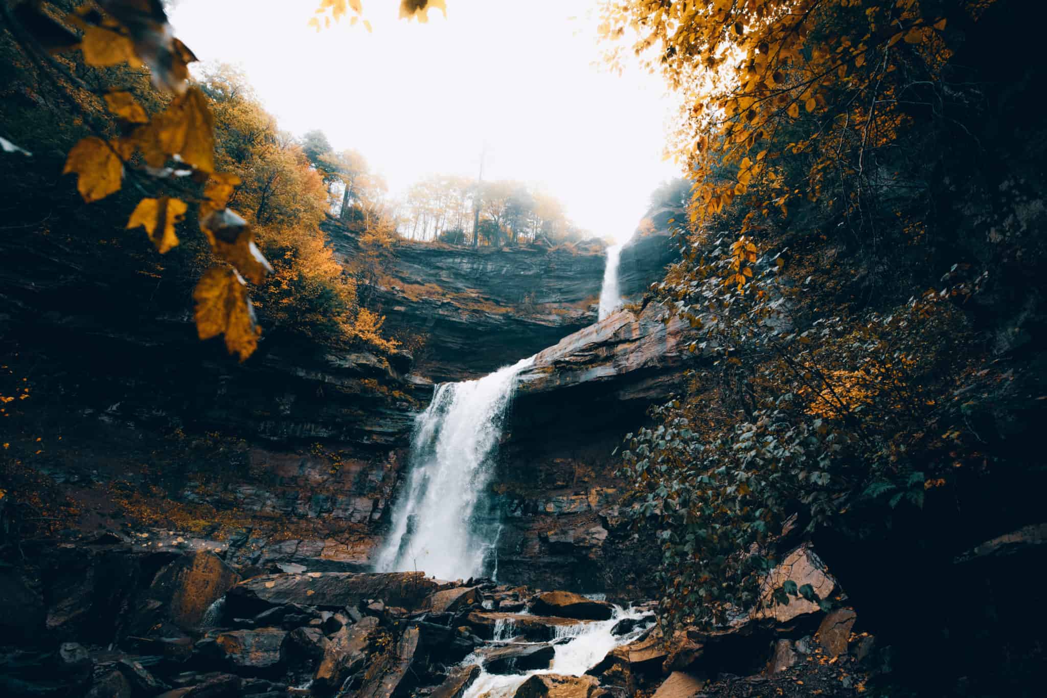
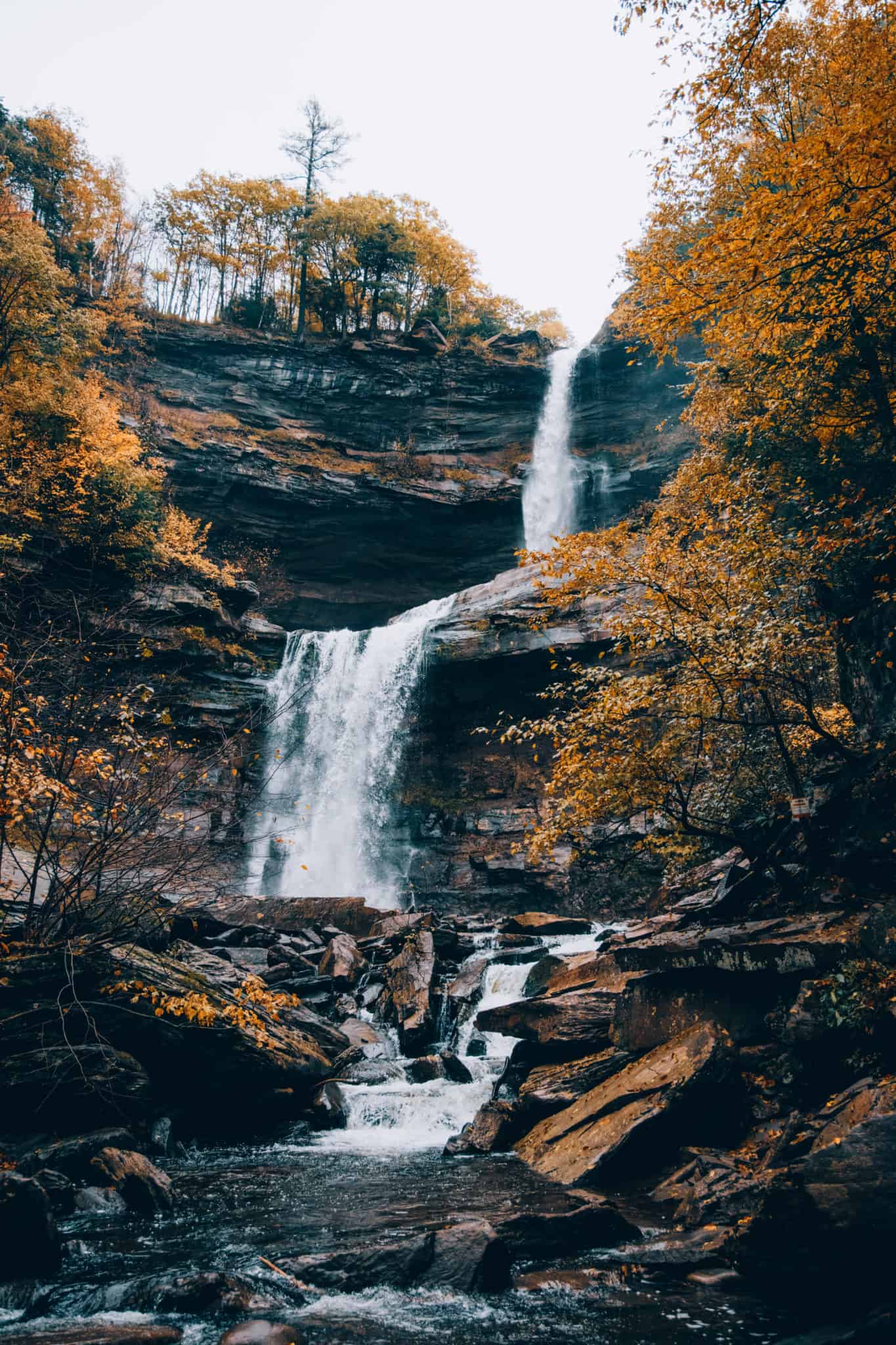
Dropping 260 feet into a lush valley filled with deciduous trees (you’ve got to see this place in the fall!), it’s a beautiful New York hiking trail worth every step.
In this post, we’re sharing our favorite route to see the falls (there’s more than one way) and what you can expect on this gorgeous Hudson Valley trail.
Let’s go outside!
The Complete Guide To Kaaterskill Falls Hike In Upstate New York (Upper Trail)
Where Is The Kaaterskill Falls Hike?
The Kaaterskill Falls hike is located in the Catskill Mountains in Greene County in New York state. It’s one of several beautiful hikes in the Catskills, which are beautiful practically all year long!
The nearest towns are Hunter, NY, Tannersville, and Haines Falls, all located around a 3-hours drive from New York City.
Here in the Kaaterskill Wild Forest, there are tons of opportunities for recreation, camping, and hiking. However, Kaaterskill Falls Hike is the most popular trail in the area!
It is very very likely that you will have company along the trail during your time here. It’s popular for a reason (it’s GORGEOUS), so plan for a small crowd!
Read More: How to Spend 3 Days In Upstate New York

Two Routes To Kaaterskill Falls
The Kaaterskill Falls Hike has two optional trail routes. Both are unique in their own way, and it’s up to you to choose the best one for you and your group.
First Option: Kaaterskill Falls Hike (From The Upper Falls), starting at Laurel House Road just before North-South Lake Campground.
Second Option: Kaaterskill Falls Hike (From The Lower Falls). We don’t recommend this trail – however, it is still available for public access. This trailhead requires a short walk on a busy highway road, and a taxing hike up to the falls from below.
In this post, we’re sharing about the UPPER Kaaterskill Falls Trail, as we believe this is an exceptionally beautiful and scenic way to reach the falls below.
Keep on reading!
What To Expect On The Kaaterskill Falls Trail (The Upper Falls Trail)
The Upper trail starts on Laurel House Trail. Here are the coordinates to the parking lot: 42.19577, -74.06303
To reach this Upper Falls trailhead, type in ‘Kaaterskill Falls Viewing Platform’ into Google Maps and it should take you up to the correct starting point.
DO NOT type in “Kaaterskill Falls Trailhead”, because it will direct you to the Lower Falls Trail…which is fine, but we’re not talking about that route in this post so you’ll be very confused.
Here are a few driving directions:
- On Route 23A in the town of Haines Falls, go north on Route 18 towards North-South Lake Campground.
- Before the campground, look for Laurel House Road to the right. Park in the parking lot.
Once at the correct parking area, there’s a sign in a lot with interesting information about Kaaterskil Falls, so it’s worth a read if you have time.
To continue on the trail, take the large gravel path to the left and walk amongst a row of tall, symmetrical trees.


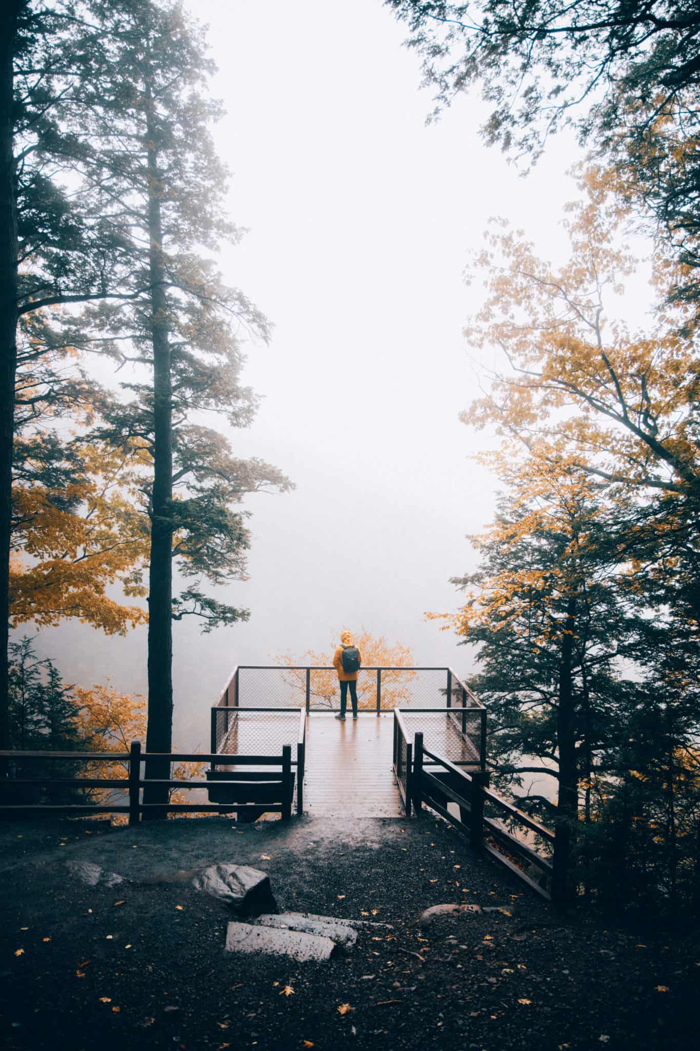
The Kaaterskill Falls Viewing Platform
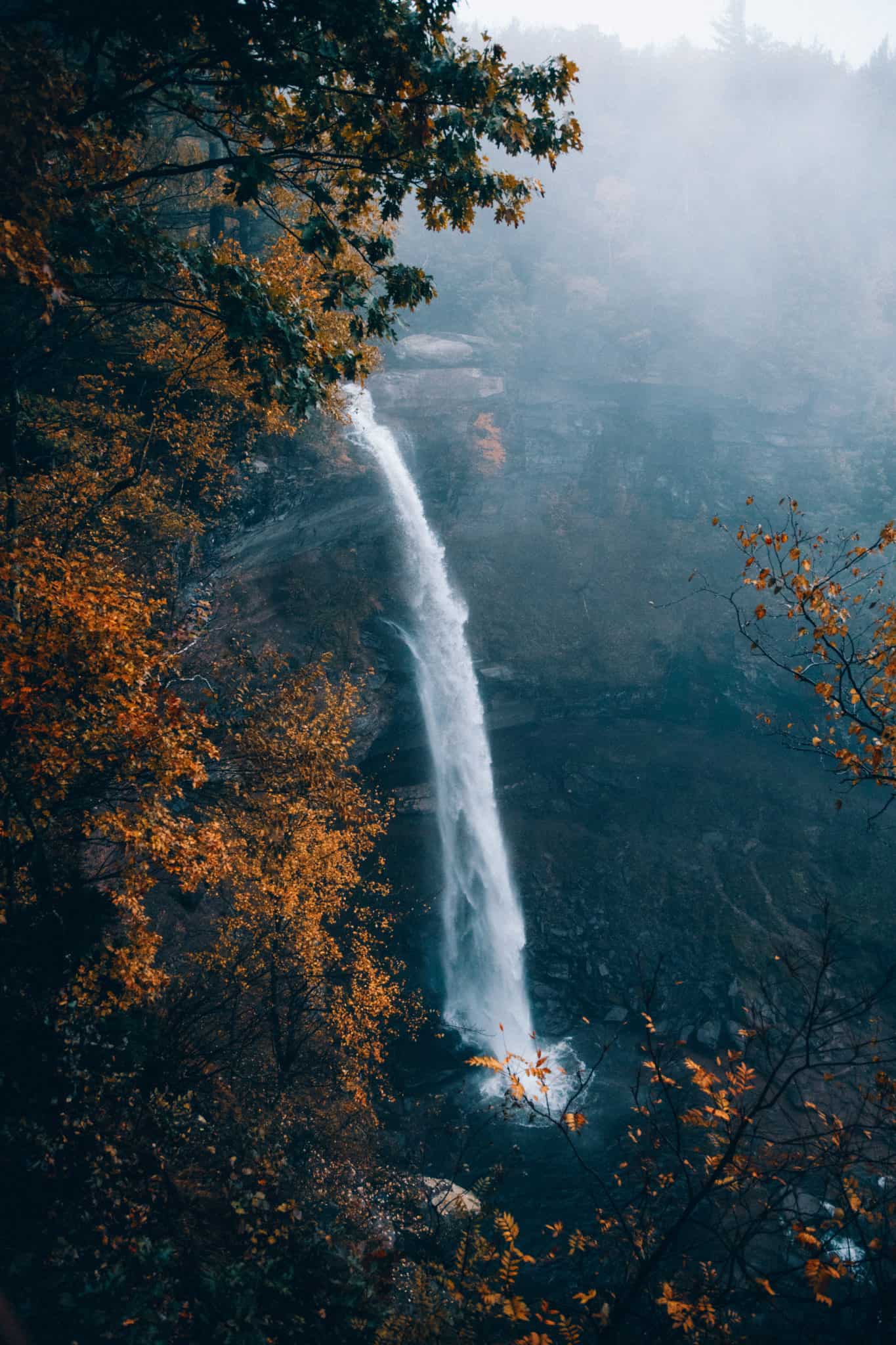
Not long after you’ve started your Kaaterskill Falls hike, you will have the option to take a quick side trail to view the falls from above.
We highly recommend stopping for photos. After a particularly rainy period, this 260-foot double-tiered waterfall is quite powerful and majestic!
You’ll also get a glimpse of what you will be able to see from the base of the falls. Taking the Kaaterskill Falls Upper Trail, you’ll wrap around the back of the falls and make your way down on the other side to the base.
The Trail To The Base of Kaaterskill Falls
The part of Kaaterskill Falls hike that wraps around the back of the falls is quite uneventful.
You’ll make your way through the trees, crossing a bridge over Spruce Creek. After the bridge crossing, look for a junction and take the direction towards Lower Falls, Layman’s Monument, and Inspiration Point.
From here, the path is rocky and bumpy. Watch your step!
Just about 1/10 of a mile ahead, you’ll have to make your next decision. Inspiration Point, Layman’s Monument, or making your way down to the Lower Falls.
All are great routes, but for the sake of this post, we’re heading down to the Lower Falls.
*Word of Caution: Many parts of this hike don’t have guard rails and get quite close to the edge of the falls.
Deaths are not uncommon here (read that once more and let it really sink in), and the most common cause is from people posing for photos too close to the edges of the cliffs. The best way to prevent this kind of death is to STAY ON THE TRAIL.

Access between the Upper and Lower Falls used to be extremely dangerous, but in recent years it’s been established for public use.
You’ll finally reach a loooonnngggg set of stairs with 375 feet of elevation in 0.4 miles (0.8 miles round trip from the junction point to the bottom).
It’s quite easy to get down, but prepare to peel off those layers as you make your way back up at the end! It got our hearts pumping!


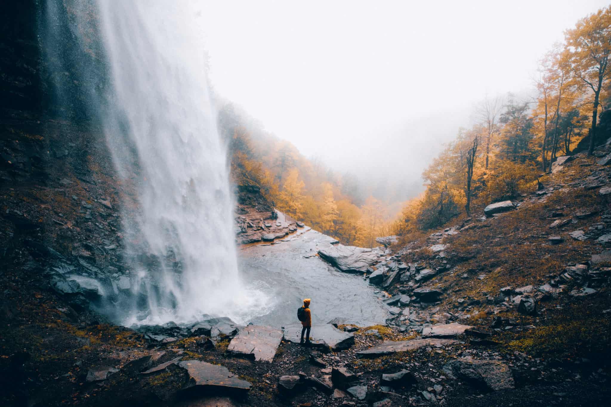
The Base Of Kaaterskill Falls
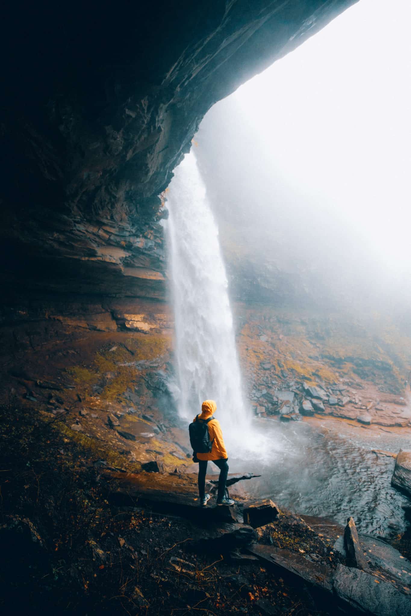
After the long set of stairs, you finally get your first glimpse of the base of the falls (and even feel the mist on your face!).
Kaaterskill Falls is a two-tiered drop, that majestically stretches 260 feet tall!
On our last visit (October 2018), we noticed that the base of the falls seemed a little primitive and rocky, despite the heavy usage this trail gets throughout the year.
We encourage you to watch your step as you roam around the base. We observed a few people trying to cross the creek at precarious locations which resulted in wet shoes and potentially dangerous situations.
The rocks were also quite slippery after a heavy rain! Just watch where you step and you should be alright.


And yes, there is access under the falls! From this perspective, you can see Kaaterskill Falls from behind, which is a really incredible picture in the fall.

Finally, Make Your Way Back The Way You Came!
The trip back was exactly the way we came down, just with a million stairs up instead!
However, with all the huffing and puffing at the end, we would do it all over again to see these amazing New York waterfall views.
If you’re looking for a beautiful hike in Upstate New York, we hope you’ll consider taking the Kaaterskill Falls hike. It’s an incredible way to spend a fall afternoon and experience one of New York’s forest gems!
Have you ever done the Kaaterskill Falls hike? Did you take the Upper Trail or the Lower Trail? Tag us in your photos and share them with the hashtag #themandagies on Instagram!
MORE EAST COAST ADVENTURES
Amazing Photography Spots In Cleveland, Ohio
The Photographers Guide To Cuyahoga Valley National Park
The Perfect 3 Day Weekend In Upstate New York
The Ultimate Guide To Instagram Spots in New York City (NYC)